 aPhantom.net
 Bahamas 2014 Part 2
Click Here for the Photo Gallery
Armed with a forecast of beautiful weather for several days, we were convinced it was time to make our passage to the Bahamas. At nine-thirty in the morning we left our mooring in Vero Beach and made the short trip to the fuel dock to top up our fuel and water. It is about twelve miles on the Intracoastal Waterway from Vero Beach to Fort Pierce. The inlet here is wide and well marked and was being well used by pleasure boats and fishermen on this fine Saturday in April.
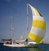
We reached the sea buoy marking the outside channel at about noon. The weather prediction was exactly correct this time and we set sail in about a ten knot northwesterly breeze. The Gulf Stream is only about fifteen miles offshore at this location so it wasn't long until we saw the beautiful deep blue colors marking the fast moving current and deeper water. We would normally not be anywhere near "The Stream" in any kind of north wind but this prediction by the weather guru called for nothing more than about ten knots and that it wouldn't last more than a day, to be replaced by the normal light southeasterly breezes. If we waited for the next day, we would be motoring the whole way. A chance to sail at least part of the way with a favorable wind seemed like a better choice to us. And so it was. It was time to shake all the spiders and dust off the sails and remember why we have a sail boat.
The wind held steady until about ten-thirty at which time we were about sixty miles from the nearest land. We got to sail about half way to our destination before adding the motor which was about what we had expected from the weather forecast. There was absolutely no moon in a perfectly clear night sky. When one finally gets away from the glowing lights of land, the stars become too numerous to identify and the darkness seems complete. Our small navigation lights seem pretty feeble in so much darkness.
Meeting another vessel at night on a whole big ocean seems unlikely; however, one can seldom cross this bit of water without coming across at least one or two large commercial ships. Trying to identify the size, direction of travel, and distance to one of these giants can be quite challenging at night. A new addition to our navigation electronics last year was a very handy gadget called AIS (Automatic Identification System). This little gem connects to a ship's navigation system and broadcasts the name, size, speed, direction of travel, and intended destination of any vessel equipped with this tiny transmitter. All passenger ships and commercial vehicles of 300 tons or more are required to have this piece of equipment on board. These units have recently become available and affordable for pleasure boats and in our opinion, one of the most useful items aboard. Now we can simply look at the GPS display and know what ships are in the vicinity and if there is any chance that we will both be on the same piece of ocean at the same time. There is also an alarm that can be activated for a selected distance.
We had been watching a large container ship that was heading north to Jacksonville according to the AIS. As we were now able to identify the ship by name, we were able to call on the VHF radio, just to make sure they knew that we were here and that someone on that big ship was actually on watch. On a big dark ocean, this is a very comforting thought. We were about to change course and let this big guy pass ahead of us, but the radio operator said it was much easier for him to adjust his heading a few degrees and pass well behind us. That was enough to depreciate the entire cost of the AIS unit as far as we were concerned. Collision avoided, we continued on our way.
We passed out of the Gulf Stream and onto the Little Bahama Bank at Matanilla Shoal about two-thirty in the morning. The water depth here is about thirty feet deep everywhere with a mostly sandy bottom so it wasn't a problem to continue on in the darkness. The only noticeable difference was a slight change in the ocean swell as the water depth came up quickly from the thousand foot depths. Our destination at Great Sale Cay was still forty-five miles away.
Soon the sun was up and we found ourselves surrounded by the beautiful blue waters of the Bahamas. If you see any of those pictures taken from space, the Bahamas are always easy to identify because of the water colors, it really is quite amazing. The light east wind filled in as promised and we reached our anchorage at about noon, making the trip from the Fort Pierce Sea Buoy to our anchorage almost exactly twenty-four hours.
We were ready for a nice lunch and a nap which was exactly what we did. A delightfully cool breeze continued through the night, perfect for sleeping and re-grouping. Great Sale Cay is just a low, uninhabited island so we were content to stay just where we were and enjoy the scenery.
 Rested and refreshed, we were ready for our next port of call, Spanish Cay. On this small island there is a five thousand foot private runway and a full time customs agent who comes from the mainland of Abaco each day on the island ferry and returns on the four p.m. ferry. By the time we arrived we had only about thirty minutes to complete our check-in procedure and be officially welcomed to the Bahamas. We hoisted our Bahamas courtesy flag and were ready for the fun to begin. Dinner and drinks at the friendly bar completed the evening.
Our next stop was Green Turtle Cay. There is a small settlement here and two fairly well protected harbors, Black Sound and White Sound. We planned to meet our friends from Florida here and had planned to stay at the Bluff House Marina for a few days. We arrived at the outer harbor at about three in the afternoon, the exact time of low tide. The chart for White Sound shows a couple of five foot places in the channel to the marina and as it was just a day after the new moon, the low tide was about one-half foot lower than normal. There was no way our six foot draft was going to make it in to the harbor any time soon. A call to the marina informed us that the channel had been "recently" dredged to seven feet. If we waited until about half tide when we would be comfortable with the water depths, we might be too late to get a helping hand for docking from the marina staff. All of this seemed just a bit dicey to us so we decided to anchor just outside of White Sound and come in on the morning rising tide. More cool breezes and settled weather made this another lovely night at anchor.
The next morning we weighed anchor and were inside the harbor and tied up at the marina by about ten a.m.  Our friends arrived to greet us and we were ready to enjoy the sights of Green Turtle Cay. The marina had made many improvements since the last time we were here including a new restaurant and beach bar on the Sea of Abaco. It sounded like the perfect place for lunch. The special for the day was fresh grouper from the local waters and it was delicious. But that is where the trouble began. It seemed that this particular grouper contained the toxins for a type of food borne Illness called ciguatera. Other than the standard "food poisoning" symptoms, this produced a strange sensitivity to cold, (an ice cold glass felt very hot to the touch), and just a general dragged out feeling. The recommendations for treatment, of which there were very few, included avoiding all fish (no kidding) and also avoiding all alcohol.
So let's get this straight. Here we are in one of the best places in the world for fresh fish and tropical drinks and we are to avoid both? It just didn't seem fair. We decided to stay a few extra days at the marina for rest and recuperation. It seemed that our beer and wine supply was going to last a lot longer than we had originally anticipated.
Click Here for the Photo Gallery. It is best viewed full screen, click bottom right of gallery screen for full screen view.
Click Here for Part One.